
GLONASS + Beidou Satellite Systems are to be joined as a unitary global navigation satellite system.It will cover well beyond Russia and China, as it will be the Eurasian satellite system. Of course, both are global systems tuned heavily to Russian and Chinese requirements and available to any public user anywhere on Earth.
Two-thirds of world’s population will no longer be dependent on GPS or the EU’s Galileo system. Russia’s global coverage has been in service to the entire world since 2011. It has an accuracy rating of 4.5 meters for public use. China’s BeiDou is still limited to Asia-Pacific region, but will go global in 2020. Presently, its accuracy for public use is 10 meters. But has military encrypted accuracy of 0.1 meters.
What this integration of the two systems means is extreme accuracy for geo-positioning needs in navigation, location, mapping and transportation.
There is also a plethora of military security issues that are served by the Russian-China merger of their national systems.
Picture the globe marked by a massive land area surrounded by military(s) intent on choking off trade routes, commodities, food, fuel, products and opposing navies.

That is the world according to the Hegemon.
One of the coercive tools used to control the land mass was in near Space—GPS satellites. American technology, hegemonic gatekeeping for many years.
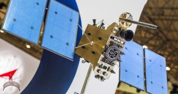
Russia broke from the limitation of US-owned satellite system with GLONASS, its own navigation satellite system. Soon after, China began its own system—BeiDou.
While developing the Chinese version, China began to use the Russian system for tracking its shipments and transport. Concurrent with the reliance on Russian civilian technology, the Chinese have also adopted and adapted Russian military technology.
The two giant super powers are moving to integrated missile defense systems, based on S-400 systems. China has begun receiving its first units of the world-class missile defense. Having observed the use of the S-400 in Syria (its mere presence is ‘use’, for it forces the US and Israel to stand off or not fly without Russian ‘de-confliction’ permission.)
Meanwhile, in Space, the Chinese have seen the value of integration and redundancy. Thus, we have the announcement that henceforth, the GLONASS and BeiDou systems will be integrated. This adds accuracy for all the civilian and military links to navigation, location, mapping, remote sensing and security intelligence data.
Now look at the massive, mostly uncharted landmass of Eurasia.

Thousands of kilometers of deserts, mountains, gorges, cliffs, plateaus, tundra, arctic ice, rivers, lakes, inland seas, villages, towns, settlements and cities all of which are destined to be impacted by OBOR, New Silk Road, EAEU and SCO actions.

Infrastructure, like rail, roads, fiber optic and pipelines demand mapping accuracy (surveying) to millimeters. The first stage of such remote sensing can take it to 3-6 inches. On the ground, using those maps (guided by navigation satellites) the precise accuracy is made possible. Even underwater accuracy by LIDAR sensors is guided by satellites. Thus, the actual development of Belts and Roads Initiative (BRI) projects begins from Space.

What the Chinese and Russian construction engineers and project planners will use now is a highly accurate, proprietary to Eurasia, navigational system the Hegemon does not control.
Sadly, as often is the case, India is not participating, hoping to build its own or with Japan’s, an alternative system. India will benefit, nonetheless from Eurasian development. It’s flirtations and alignments with the Hegemon the sort of policy that has always left India lagging.
What is seemingly a civilian integration by China and Russia—the duo I named the Double Helix—is one of many technological integrations, most of which have military dual use or buttress military use.
The military navigation applications in current use, facilitate forces location, forces navigation, forces deployment, all weather and around the clock operations, and communication network timing.
In later presentation, I will expand on the four years of integration that has progressed with the Double Helix since my White Paper published here at the Vineyard.

Be assured that President Putin and President Xi have absolute recognition of the existential threat of containment, destabilization, use of terrorists, aggressive NATO encroachment, placement of THAAD missile systems (radars of which neutralize China’s second strike capabilities), and new aggressive basing close to Russia and China’s borders and along the intended routes of the Eurasian development.
The Russian development of the Arctic is a good place to watch this as routes and specialized ships open a safe passage for Chinese shippers. Russia is also quickly militarizing strategic locations now accessible.

The development of Russian naval forces and bases in the Asia Pacific region now link with the extensive eastern ports of China to the South China Sea (and beyond for Russia to Vietnam). As we know, Russia has a very large nuclear submarine fleet, which joined with the Chinese submarine capacity, will be a match for the enormously powerful US subsea arms. The two partner navies have exercised annually to sharpen skills and build unity, if needed.
Importantly, satellites and submarines are linked. Yes, military satellites for communications are separate from the navigational systems, but both systems work in tandem at times.
Thus, the order of battle begins in Space with navigational systems, links to aerospace for some munitions and machines, and links to land forces and naval surface and subsea vessels.
China and Russia are quickstepping their special partnership. Some items we see and hear about, others are hidden. GLONASS and BeiDou are now going to fly as brothers in arms.